Good afternoon Island residents,
The Town continues to monitor the development of Hurricane Dorian. At this time the key things to note are:
- The National Hurricane Center is calling for additional intensification which makes Dorian an extremely dangerous and major hurricane.
- The forward speed of the Hurricane Dorian is moving slowly to the northwest at just over 10mph.
- The potential for Hurricane Dorian to have significant impacts on South Carolina remain. Several models have the storm landfall in central Florida then tracking northward. The position of the curve north will dictate impact to South Carolina. Notwithstanding wind, this looks to be a major rain event for the Island. It may be early next week before a more reliable prediction of the track is available.
- The Town remains on standby until Hurricane Dorian no longer poses a threat to the Island. These messages will continue until no longer necessary.
- The prevailing north/northeast wind has resulted in very strong rip currents running parallel to the beach on Sullivan’s Island. Today 5 people nearly drowned before being rescued by the Fire Department using the jet skis. REFRAIN OR USE CAUTION IF YOU ENTER THE OCEAN. Conditions around the sandbars and inlets can be treacherous.
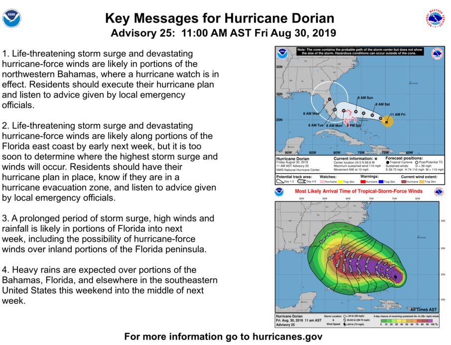
This is the latest information available based on advisories/publications from the National Hurricane Center and the Town’s participation in meetings with Charleston County Emergency Management Department as of 12:30PM Friday. Note that while the format is the same as previous messages, information has changed. Please read this message in its entirety.
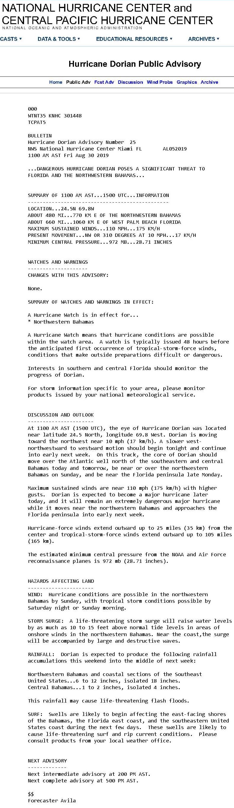
- Hurricane Dorian – Current Conditions and Projections from National Hurricane Center Advisory 25 at 11:00am
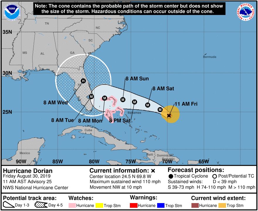
- Location: 24.5N 69.8W (approximately 725 nautical miles southeast of Sullivan’s Island)
- Maximum sustained winds at 110 mph
- Present movement is to the NW at 10 mph
- Central pressure is 28.1” or 972 mb
- Current models have landfall in central Florida as a Category 4 storm with maximum sustained winds up to 140mph late Monday; however, the location of landfall is still subject to change
- What to expect
- The NHC anticipates rapid intensification as the storm moves to the west of the Bahamas; at time of landfall the storm could be a Category 4 hurricane with wind at 140 mph
- Based on the 11am observations:
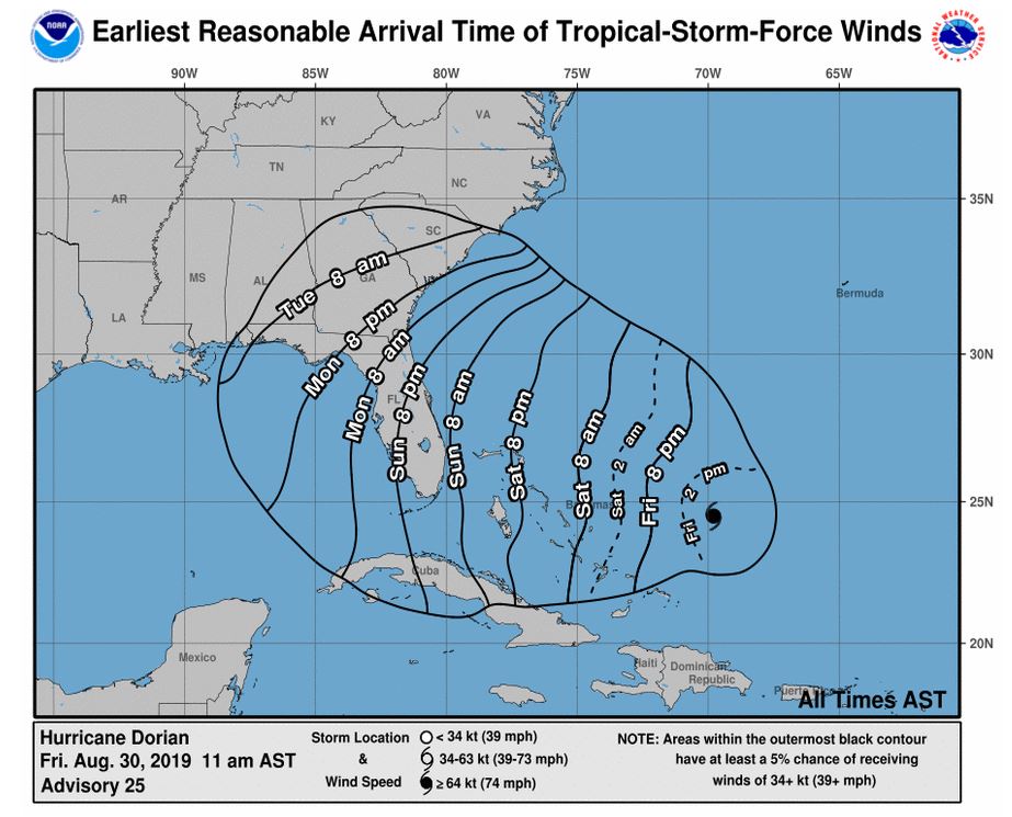
- Landfall could be in central Florida late Monday 09-02-19
- While several of the tracking models are in agreement, the storm has yet to enter the warm water of the Caribbean. Likewise, there are weather systems that can impact the tracking which could result in a more northward swing resulting in more severe impact for South Carolina
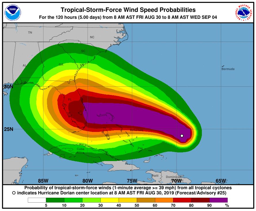
- At the present course, Sullivan’s Island could experience increased wind up to 30mph by late Monday early Tuesday
- Rainfall should begin to increase Sunday/Monday
- Take note of the tide cycle and prepare for local shallow flooding with somewhat higher tides and north/northeast wind; tides for Sullivan’s Island will range from 6.3’ to 6.8 feet at flood slack water with a driving north/northeast wind
- Swell height and rip current will begin to increase once Hurricane Dorian moves past the Bahama islands
- Significant rainfall on Sullivan’s Island next week likely
- As a resident what should you be doing at this time
- Continue to monitor local media outlets for the latest information on the hurricane; the storm can still take a more northerly track toward Sullivan’s Island
- Review your family hurricane plan and begin to consider what you will do if the storm tracks north
- Exercise caution when boating, swimming or surfing
- Be vigilant of local coastal flooding
- Do not place any bulk debris or landscaping materials street side for Wednesday pick-up until further notice; Friday 8-30-19 household garbage will occur as scheduled but remember to move your cart away from the street Friday evening
- The Fire Station has empty sandbags available
- What the Town is doing
- The state of SC, Charleston County and Town of Sullivan’s Island remain at OPCON 3 – business as usual but standing by in the ready
- Town staff participates daily in status meetings with SCEMD, Charleston County EMD, NWS-Charleston and a host of other federal, state and local jurisdictions for the latest storm preparations
- Town staff is on notice for hurricane schedule activation
- Preliminary preparations to secure the Town assets have been completed
Please monitor the latest conditions of the hurricane through the local media outlets. The hurricane track still remains somewhat fluid.
Reverting tomorrow after the regional hurricane meeting.
Regards,
Andy Benke
Town Administrator
Town of Sullivan's Island
 The Official Web Site of the State of South Carolina