The Official Web Site of the State of South Carolina

Hurricane Dorian- Message #2

Thu, 08/29/2019

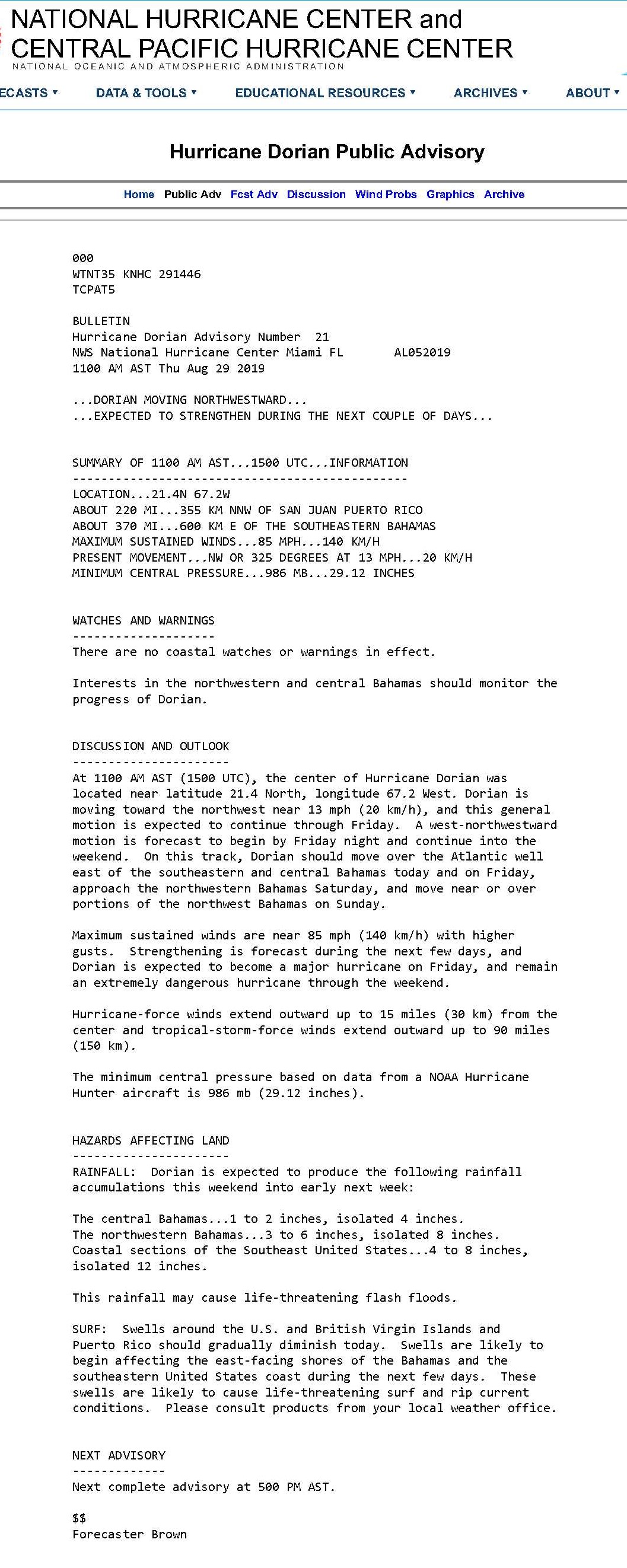
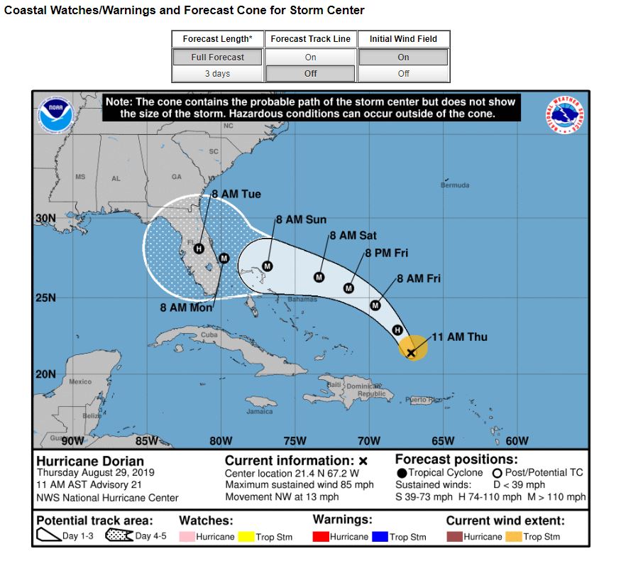
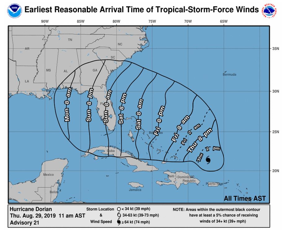
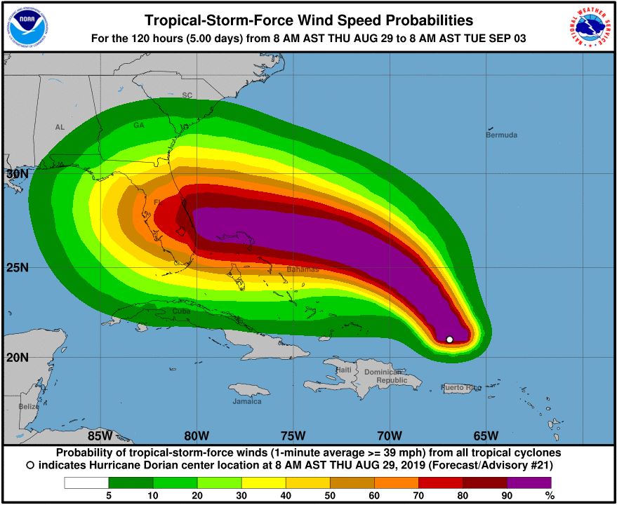
Good afternoon Island residents,

This is the latest information available based on publications from the National Hurricane Center and the Town’s participation in meetings with Charleston County Emergency Management Department as of 12:30PM today.

  • Hurricane Dorian – Current Conditions and Projections from National Hurricane Center Advisory 21 at 11:00am
    • Location: 21.4N 67.2W (approximately 958 nautical miles southeast of Sullivan’s Island)
    • Maximum sustained winds at 85 mph
    • Present movement is to the NW at 13 mph
    • Central pressure is 29.12” or 986 mb
    • Current models have landfall in central Florida as a Category 4 storm; however, the location of landfall is still subject to change.
  • What to expect
    • The NHC anticipates rapid intensification in the next 48 hours as the storm moves to the west of the Bahamas; at time of landfall the storm could be a Category 4 hurricane with wind at 130 mph
    • Based on the 11am observations:
      • Landfall could be in central Florida as early as 8am Monday 09-02-19
      • While several of the tracking models are in agreement, the storm has yet to enter the warm water of the Caribbean. Likewise, there are weather systems that can impact the tracking which could result in a more northward swing
      • At the present course, Sullivan’s Island could experience increased wind by Sunday 09-01-19 up to 20 mph
      • Rainfall should begin to increase Sunday/Monday
      • Take note of the tide cycle and prepare for local shallow flooding with somewhat higher tides and north/northeast wind
      • Swell height and rip current will begin to increase once Hurricane Dorian moves past the Bahama islands
         
  • As a resident what should you be doing at this time
    • Continue to monitor local media outlets for the latest information on the hurricane; the storm can still take a more northerly track toward Sullivan’s Island
    • Review your family hurricane plan and begin to consider what you will do if the storm tracks north
    • Exercise caution when boating, swimming or surfing
    • Be vigilant of local coastal flooding
    • Do not place any bulk debris or landscaping materials street side for Wednesday pick-up until further notice; Friday 8-30-19 household garbage will occur as scheduled but remember to move your cart away from the street Friday evening
       
  • What the Town is doing
    • The state of SC, Charleston County and Town of Sullivan’s Island remain at OPCON 3 – business as usual but standing by in the ready
    • Town staff participates daily in status meetings with SCEMD, Charleston County EMD, NWS-Charleston and a host of other federal, state and local jurisdictions for the latest storm preparations
    • Town staff is on notice for hurricane schedule activation
    • Preliminary preparations to secure the Town assets have been completed

Please monitor the latest conditions of the hurricane through the local media outlets.

Reverting tomorrow after the regional hurricane meeting.

Regards,

Andy Benke
Town Administrator
Town of Sullivan's Island


Hurricane Dorian Public AdvisoryForecast Cone Reasonable Arrival Time of Tropical Storm Force WindsTropical Storm Force Wind Speed Probabilities